New Zealand fishing intelligence
See like a gannet
Your AI fishing co-pilot for NZ waters. Gannet reads the tide, wind, swell and sea temperature — and your own logbook — so you know where to be before you launch.
Built for iPhone · Launching soon
Gannet intelligence
Think like a gannet, fish like a gannet
Gannet weighs the tide, wind, swell and sea temperature against your own logbook — your species, your spots, your seasons — and turns it into a clear read on where to go and what’s biting. The more trips you log, the sharper it gets.
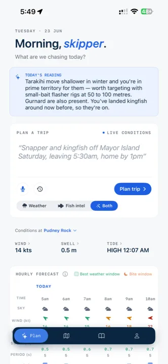
Today’s reading
“You’ve landed good kingfish here around this time before — and with the tide and water temp lining up this week, they should be on.”
What it does
The thinking you do before every trip — done for you
Gannet checks the tide, wind, swell, moon and your past trips, then ranks the best spots and windows for the day.
Gannet Intelligence
Gannet weighs the season and today’s water against your own logbook — your species, your counts, your spots — and tells you what’s likely on. Your history becomes your edge.
Made smarter by every trip
Voice-log, paste, or photograph a logbook page — Gannet pulls out species, counts and stops automatically. The more you log, the better it knows your patch.
AI trip plans, on demand
“Snapper and kingfish off Mayor Island Saturday, leaving 5:30am, home by 1pm” — Gannet turns a plain-English plan into ranked spots and the best window to fish them.
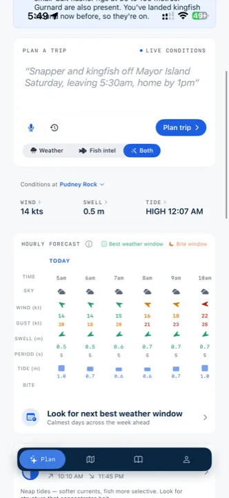
Conditions, hour by hour
Wind, swell and tide for your spots and waypoints, hour by hour — with the calmest weather window and the bite window called out across the day.
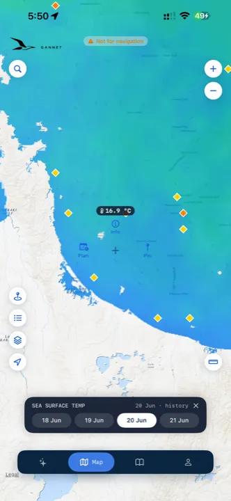
Read the water in layers
BetaSea surface temperature, AI hotspots and temperature breaks painted onto the chart — so you can see where the fish-holding water is before you leave the ramp.
An honest call
Every spot flags Go, Caution or Avoid — and Gannet tells you straight when it’s a day to stay home. A planning aid, never a push to launch.
See it in action
From plan to water
Plan
Plan around the bite window
Live conditions for your spot, hour by hour — wind, swell and tide — with the calmest weather window and the bite window marked across the day, so you leave at the right time.
See the water
BetaSee where the warm water is
The sea surface temperature layer, AI hotspots and temperature breaks painted straight onto the chart — scrub back through recent days to see how the water is moving.
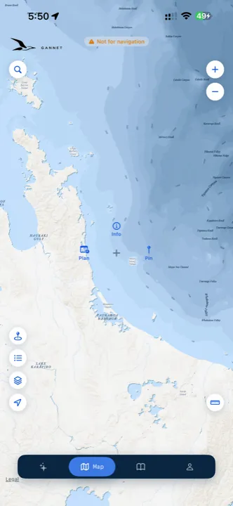
The map
Every spot on the map
Your spots, ramps and waypoints mapped across the coast. Tap any one to check the conditions, plan a trip, or drop a pin.
Who it’s for
Built for serious New Zealand fishers
From fishing the harbour in your 12ft tinny to trolling for marlin out wide — if you plan your trips around tide, wind and swell, Gannet does the thinking for you. It’s tuned to the species you target and the spots you actually fish, right across the country.
Every NZ region
Launching soon
Be the first to know
We’re putting the finishing touches on Gannet for iPhone. Join the waitlist and you’ll be the first to hear the moment it’s available.
We’ll only email you about the Gannet launch. No spam, unsubscribe any time.
Questions
Good to know
When does Gannet launch?
We’re putting the finishing touches on Gannet for iPhone. Join the waitlist above and you’ll be the first to know the moment it’s available.
How much will it cost?
Gannet is free to get started. An optional Premium tier unlocks AI trip plans, “where next?” suggestions and unlimited questions, and comes with a 14-day free trial. Final pricing will be confirmed at launch.
Is Gannet a navigation app?
No. Gannet is built for trip planning and logging — not navigation. Keep Navionics or TimeZero on board for charts, weather routing and live currents.
Is it New Zealand only?
Yes. Gannet is built specifically for New Zealand waters — tide predictions for your spots and waypoints, NZ fishing regions from Northland to Southland, and species tuned to local seasons.
What platforms is it on?
Gannet is an iPhone app. Join the waitlist to hear about other platforms as they’re announced.
How is my data handled?
Your trip log is encrypted at rest and never shared. Gannet is a planning aid — always check dedicated weather and safety apps before heading out.